
Moment Tensor Solution for the 20 Feb, 2014 Ml 4.1 Bristol Channel Earthquake
Data and Inversion ProcessWe used broadband waveforms from the British Geological Survey's seismometer network. For this earthquake, we used a total of 2 stations, each comprising 3 seismometer components.
Waveforms were initially converted to displacement by removing instrument response and integration. We used the BGS hypocentre location (longitude = 4.164°W, latitude=51.363°N). The crustal model was based on the P-wave velocity model of Booth (2010) and a constant Vp/Vs ratio of 1.77, based on Tomlison et al. (2006). For the moment tensor inversion, we used the ISOLA software package (Sokos and Zahradnik, 2008), an interactive MATLAB-based GUI. We solve for for double-couple constrained moment tensor. The frequency band for the inversion was selected based on careful analysis of signal-to-noise ratio and the stations' epicentral distance. |
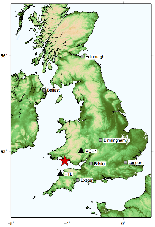
Map of BGS epicentre location (red star) and stations used for inversion (black triangles). Click for a larger version.
|
Inversion for Centroid Depth
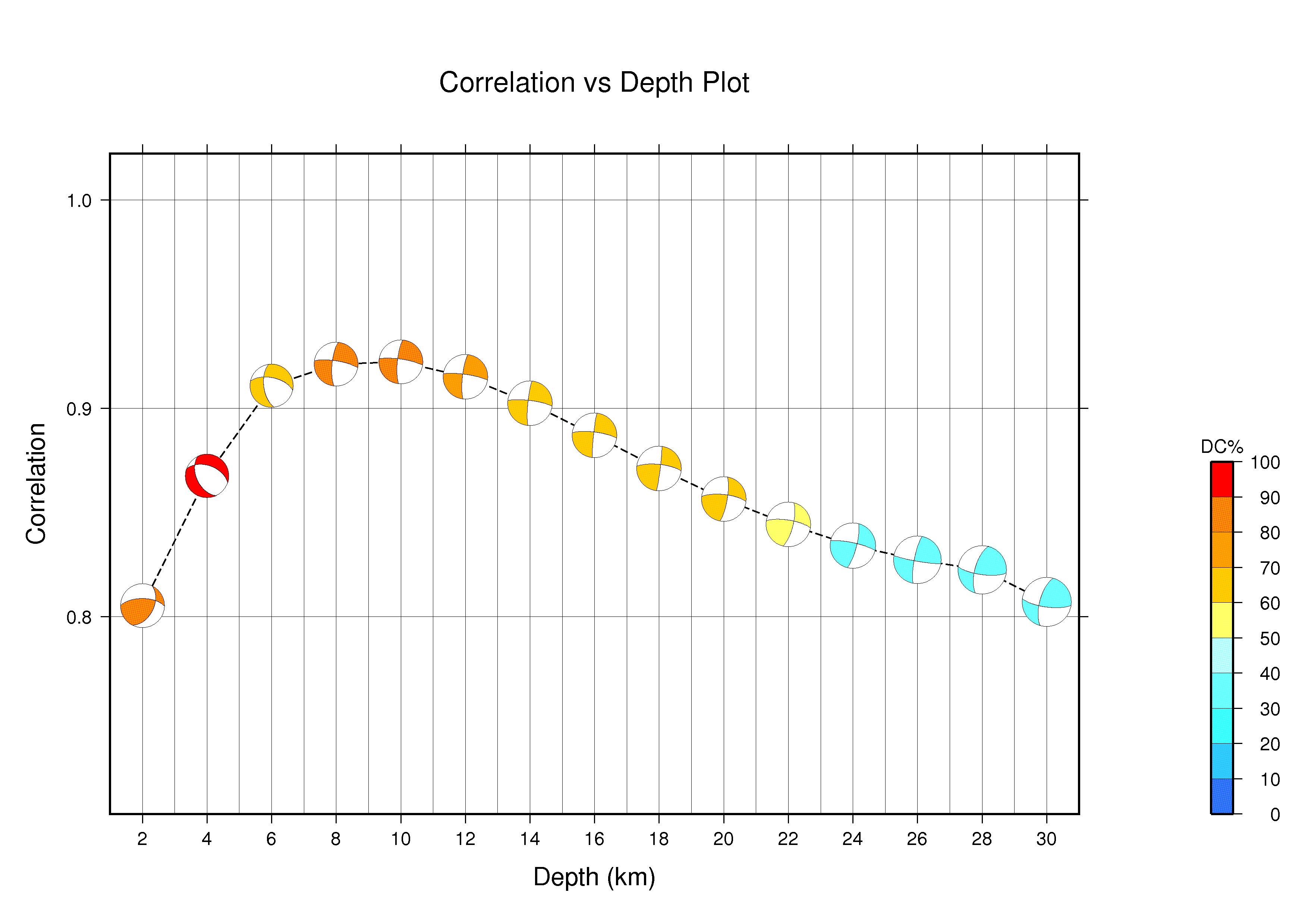
Correlation vs depth plot. Click for a larger version.
|
First, the depth of the centroid was found by keeping the epicentral coordinates fixed and by searching over a line of sources beneath the epicentre (2.5 - 11.5 km in steps of 1 km).
The highest correlation with the observed waveforms is found in the depth range 2 - 6 km, over which the focal mechanism remains stable. The best correlation with the waveforms and highest percentage double coupe is found at 2.5 km depth - this depth agrees well with the BGS hypocentre estimate of 3 km. A depth of 10 km produces a very good fit to the observed waveforms, as shown by the good variance reduction (0.48). |
Inversion for Centroid LocationThe centroid location was found by grid searching over a horizontal grid at 10 km depth. The grid was 35 x 35 km in size with a uniform spacing of 5 km.
Our analysis showed that the focal mechanism style is not vary stable across the grid. The centroid location appears unconstrained in the northwest-southeast direction, likely due to the limited station coverage. The best correlation, however, was found to lie ~6 km to the northwest of the epicentre location. This centroid location resulted in a slightly better fit to the observed waveforms and a total variance reduction of 0.49. |

Waveform correlation (contours) for a grid of trial sources at 10 km depth. Only trial sources with correlation of greater than 0.6 are shown. Click for a larger version.
|
Final Waveform Fits
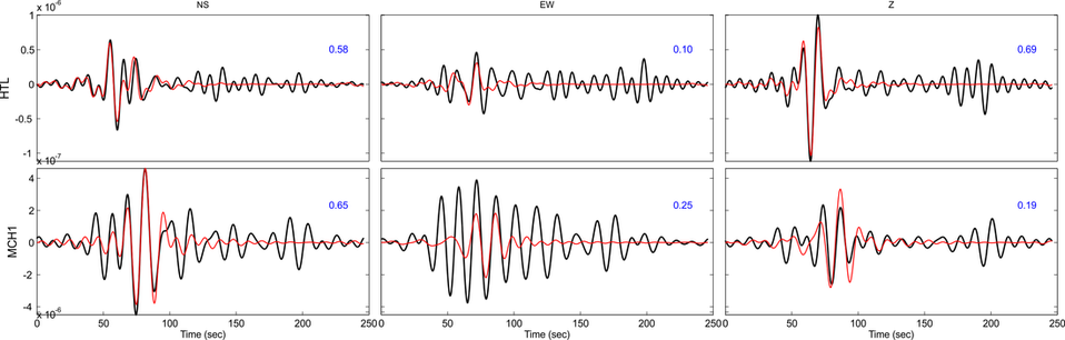
Comparison between synthetic (red) and observed (black) waveforms used in the inversion. Variance reduction for each waveform is shown in blue.
Best-fitting Solution
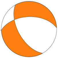
Focal mechanism of best-fitting moment tensor solution
Technical parameters
Origin Time: 20140220 13:21:30.20 Centroid Time : +1.38 (sec) relative to origin time Centroid Lat: 51.4079°N Lon: -4.2359°W Centroid Depth: 3 km. Mw : 3.7 FP1: Strike 267° Dip 53° Rake -138° FP2: Strike 148° Dip 57° Rake -45° Moment Tensor (Nm): Exponent 10**14 Mrr: -3.023 Mtt: 3.343 Mpp: -0.321 Mrt: 0.797 Mrp: 2.137 Mtp: -2.583 DC (%) : 99.1 CLVD (%) : 0.9 Full moment tensor parameters are available as a text file. Download here. |
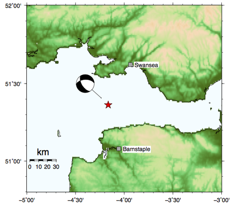
Map showing the location of the centroid and the focal mechanism. The red star is the BGS epicentre location.
|
CommentThe best-fitting moment tensor produces a focal mechanism which has oblique right lateral (dextral) strike-slip faulting (i.e. a combination of horizontal and extensional motion along a moderately-dipping fault plane oriented either NW-SE or W-E.
The Bristol Channel fault zone is a collection of geological faults that run east-west in the Bristol Channel. The Bristol Channel fault is an east-west trending normal fault that dips to the south, which formed during the Variscan orogeny in the Devonian period (Miliorizos et al., 2004). However, this fault is offset by more recent faults which trend NW-SE. Such a fault is the Sticklepath - Lustleigh fault, which extends through Devon and into Pembrokeshire, but several similar faults lie in the Bristol Channel. There is evidence that these dextral strike-slip faults have been active since the beginning of the Cenozoic (66 million years ago) due to the more recent collision along the Alpine belt. The NW-SE fault plane of the focal mechanism is consistent with the 2014 Bristol Channel earthquake occurring along a fault with a similar orientation to the Sticklepath - Lustleigh fault. Using this SolutionThis moment tensor solution is publicly available and free-to-use under a Creative Commons license (CC-BY). However, credit must be given to the author when citing this work. Citation: Hicks, Stephen (2014): The 20 Feb 2014 M4.1 Bristol Channel, UK earthquake: a preliminary moment tensor solution from full-waveform inversion. figshare. doi: http://dx.doi.org/10.6084/m9.figshare.1205046
|
Animation of oblique-slip faulting from IRIS
|
References
Booth, D.C. 2010 UK 1-D regional velocity models by analysis of variance of P-wave travel times from local earthquakes. J. Seismol., 14 (2). 197-207. doi: 10.1007/s10950-009-9160-4.
Miliorizos, M, Ruffell, A and M. Brooks. 2006. Variscan structure of the the inner Bristol Channel, UK. J. Geol. Soc., 161, 31-44. doi: 10.1144/0016-764903-035.
Sokos E.N. and Zahradnik, J. 2008 ISOLA a Fortran code and a Matlab GUI to perform multiple-point source inversion of seismic data, Computers & Geosciences, 34 (8), 967-977. doi: 10.1016/j.cageo.2007.07.005.
Tomlinson, J.P, Denton, P., Magure, P.K.H., Booth, D.C. 2006. Analysis of the crustal velocity structure of the British Isles using teleseismic receiver functions. Geophys. J. Int., 167, 223-237. doi: 10.111/j.1365-246X.2006.03044.
Miliorizos, M, Ruffell, A and M. Brooks. 2006. Variscan structure of the the inner Bristol Channel, UK. J. Geol. Soc., 161, 31-44. doi: 10.1144/0016-764903-035.
Sokos E.N. and Zahradnik, J. 2008 ISOLA a Fortran code and a Matlab GUI to perform multiple-point source inversion of seismic data, Computers & Geosciences, 34 (8), 967-977. doi: 10.1016/j.cageo.2007.07.005.
Tomlinson, J.P, Denton, P., Magure, P.K.H., Booth, D.C. 2006. Analysis of the crustal velocity structure of the British Isles using teleseismic receiver functions. Geophys. J. Int., 167, 223-237. doi: 10.111/j.1365-246X.2006.03044.
